When our village was formed, almost all of the homes were located close to the railroad depot. But, as the town grew, things got more complicated.
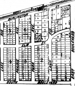
Early Map of Old Town South
When Western Springs’ streets were first laid out, the eastern-most border was what is now Wolf Road. So, for many years it was named “East Boulevard.” And, since 47th Street was the southern-most boundary, it was named “South Boulevard”. As the town grew, these streets were re-named.
There were also a number of other name changes over the years, among them:
Today’s Name Previous Name
Central Avenue Lake Avenue
Lawn Avenue Ashland Avenue
Woodland Avenue Prairie Avenue
Grand Avenue Park Avenue
Johnson Avenue Townsend Avenue
Franklin Avenue Ohio Avenue
But, these weren’t the only street-related changes. For many years, residents didn’t really have street addresses, as they do today. For example, the 1912 Western Springs telephone directory simply showed the name of the street on which someone lived. Or, in some cases, the corner nearest the resident’s home would be shown. After all, in a town of less than 1,000 residents, everyone knew where everyone else lived.
But, as the town grew and visitors started having trouble locating homes, a house numbering system was needed. In response, the village decided that homes and businesses in the blocks just north and south of the railroad tracks would be given addresses ranging from 1 to 99, with the second block (north and south) starting with 100, the third block with 200, etc. In fact, a variation of this system is still used by La Grange and Hinsdale.
In 1927, the village board decided to abandon the old address system and adopted the “Philadelphia System”, which called for 800 numbers per mile. Homes on the east side of a street were given odd numbers and those on the west side were assigned even ones. This new numbering system closely resembled that which had been previously adopted by Chicago and Downers Grove.
Specifically, the railroad tracks were no longer used as a north/south reference point. Instead, homes in the first block south of Ogden Avenue were assigned address numbers starting with 3800 (corresponding to 38th street in Chicago), the next block south with numbers starting with 3900, and so forth.
As you might expect, some homeowners were slow to accept these changes. After all, taking down all those numbers, buying new ones, and then putting them up took time and energy. So, to accelerate the public’s acceptance of the new numbers, the village announced that the post office would no longer deliver mail to any household that was not properly marked.
Apparently, the threat worked. But, even to this day, some residents have reported finding the shadow or outline of the old numerals on their homes.