In the early days of aviation, pilots often navigated using various landmarks. But, they could easily become lost in less familiar surroundings.
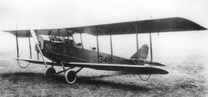
Curtiss “Jenny” aircraft – circa 1920
Following World War I, a large number of surplus military airplanes and former military pilots spawned a huge increase in aviation in the United States. But, as these pilots flew greater distances, they needed more than a road map to find their way. As one pilot noted, “When we’re uncertain where we are, we can’t pull over and ask a stranger for directions.”
So, beginning in 1926, the federal government began promoting “air marking”, which consisted of painting the name of a town on a roof or other location, along with an arrow pointing north. While government officials required that the letters be 10 to 30 feet tall, they didn’t provide any funds or manpower to accomplish the task. But, they did try to encourage numerous organizations, including the Boy Scouts, to embark on this effort to improve air safety.
In Western Springs, this project caught the attention of the veterans of the Harry G. Maxted Post. So, after determining the government’s design requirements, they approached the village’s Park District for permission to place a “Western Springs” sign (and an arrow pointing north) in what was then called the “new park”, now known as Spring Rock Park.
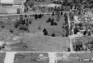
The “New Park” with 47th Street in foreground – circa 1926
The veterans decided that each of the letters should be 26 feet high by 20 feet wide, with 8 feet of separation between each letter. The building materials would consist of a background of black cinders provided by the Burlington Railroad. These would be held in place by oil supplied by a local gasoline station. The letters themselves would be made from crushed rock which would be whitewashed. The sign would be located at the south end of the park along 47th Street.
All of the materials and labor were donated free of charge and the sign was completed just before Christmas of 1933. Unfortunately, it is not known how many aviators were helped by the “Western Springs” sign over the years, or exactly when it disappeared. The land is now used for soccer fields.
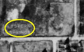
Aerial photo of the “Western Springs” sign – 1938
By 1941, an estimated 13,000 such signs had been placed on barns, buildings, hangars, oil tanks, and ground locations. But, as airborne radio use became more prevalent, such markers began to fade away. And, following the attack on Pearl Harbor and the fear of a possible mainland attack, the government ordered the removal of all such remaining signs within 300 miles of both the east and west coasts.